
Co-written with: Caleigh Shoot
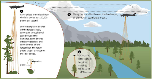
Light detection and ranging (lidar) is a popular remote sensing technology that uses laser scanning to create detailed 3D models of objects. To collect lidar data across a large area, an airplane fitted with a lidar unit flies back and forth as the device sends numerous laser pulses downward in a narrow swath. Each pulse reflects off the ground or an object above the ground (called a “return”). By measuring the time it takes for the laser pulse to return to a sensor on the device and combining that data with the position of the sensor, it is possible to calculate (spatially resolve) the 3D coordinates of each point from which the laser pulse is reflected.
The combination of all spatially resolved returns constitutes a point cloud, which is the most fundamental lidar data product. Other common products derived from point clouds are 3D ground models (also known as “bare earth”) and canopy models.
Lidar data products have many applications in forestry. Lidar can be used to map roads and streams and identify evidence of unstable slopes. With some processing, lidar can be used to identify individual trees within a forest stand and extract detailed information about each, such as tree height, crown diameter, and other forest inventory metrics. In commercial applications, lidar-derived maps of individual tree locations can be used to monitor stand density and pinpoint the application of treatments such as inter-planting, thinning, or fertilization. In ecosystem management, maps of tree locations can be used to plan thinnings to restore heterogeneous spatial patterns, and flights before and after thinning can be used to monitor treatment efficacy. The broad utility of lidar data has made it an indispensable part of forest management in the region.
An exciting, recent development in lidar technology is the ability to collect lidar using unmanned aerial vehicles (UAVs, also known as drones). UAVs have been used by hobbyists and the commercial industry for years; however, lidar units have been too heavy, power-hungry, and complex to be flown on UAVs until recently.
UAV lidar has tremendous promise to complement airplane-based data. While publicly available airplane-based lidar for most of Washington State is collected by the Department of Natural Resources at 5 to 10 year intervals, UAV lidar is economical to collect much more frequently and for small areas. It also boasts a higher level of detail and accuracy than airplane-based lidar data, coupled with streamlined logistics for flight planning and data processing that make it available on short notice.
The fact that small, targeted flights — including repeat flights for monitoring —are finally logistically and financially feasible is perhaps the most exciting part of UAV lidar’s emergence as a commercially viable technology. A UAV-based lidar mission can be contracted for as little as $1,000, making it economical to fly as few as 10 to 15 acres or as many as 1,000 with a UAV. By comparison, it costs upward of $25,000 (often much more) to contract an airplane-based lidar mission, which is not economical for any area smaller than about 50,000 acres. In addition, UAV lidar is a very agile data source: Missions can be planned and deployed within hours, and data processing can be completed the following day. This agility makes UAV lidar a truly responsive tool for time-sensitive situations such as emergency responses to landslides, floods, or wildfires, and a flexible data source for strategic implementation of everyday management activities.
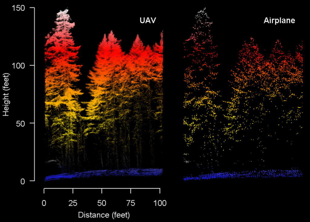
Because of its low flying height, UAV lidar has much higher resolution and accuracy than airplane-based lidar. UAV lidar often yields data with density exceeding 200 to 300 laser pulses per square meter, while the highest quality airplane-based lidar typically averages 8 to 10 laser pulses per square meter. And, each laser pulse is spatially resolved more accurately with UAV than airplane-based lidar (about 3 cm. versus 30 cm. error, respectively).
These improvements in resolution and accuracy allow for the detection of small details on surfaces and terrain, making UAV lidar ideal for mapping subtle topographic features like older landslides and barely remnant roads. And while airplane-based lidar does a remarkable job capturing forest structure over large areas, UAV lidar excels in making extremely detailed measurements over smaller areas, including much more complete maps of individual tree structures. Even in dense forests, UAV lidar captures detailed branch structures and unique branch patterns, crown shapes, most trees’ trunks, and understory structures like low vegetation and surface fuels.
Certainly, UAV data collection is not without its challenges. The Federal Aviation Administration requires a certificate to fly UAVs commercially and also imposes regulations that can present challenges to operation in remote timberlands. UAVs are required to stay within 400 feet of the ground and within visual line-of-sight of the flight team at all times, which can be difficult to maintain in the tree-covered and mountainous terrain of the Pacific Northwest. Waivers to circumvent these rules are possible but challenging to obtain. The imperative to fly safely and legally makes it all the more necessary to operate with a skilled UAV pilot and an experienced flight team.
UAV lidar is poised to fill a key role as a complement to airplane-based lidar. It will be exciting to see how the science and land management community takes advantage of this incredible tool.
3.png)
This article originally appeared in the Spring 2021 edition of The Learning Forest, a publication of the Washington Department of Natural Resources. Cathy Chauvin edited the article and created the lidar acquisition infographic.